The route
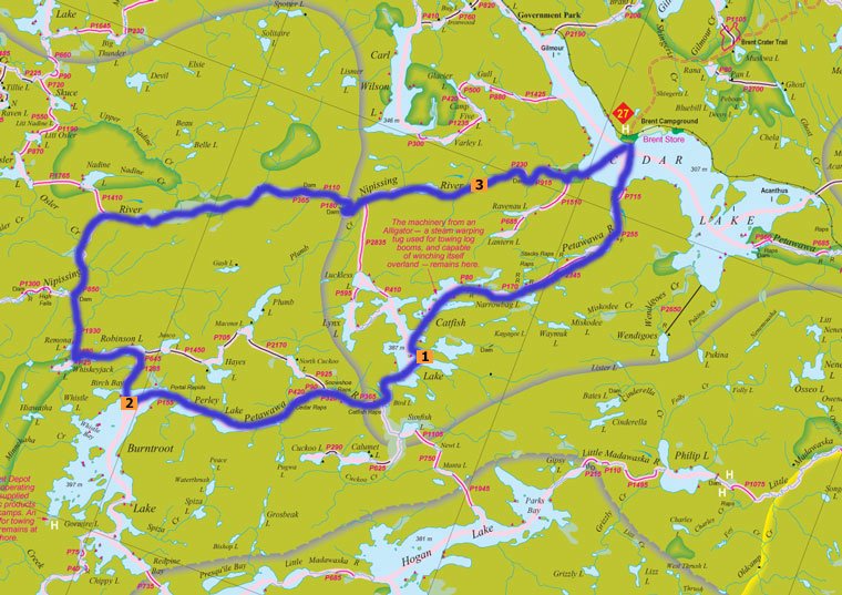 We have decided on where will be cutting our teeth this summer. It will be a "loop" that starts in Algonquin Parks northern most access point in Brent on Cedar Lake and then cut through Catfish and Burntroot lakes before slowly winding our way back up the Nippising River and returning to Cedar Lake. This will be a good challenge for both of us and it will be invaluable experience for our future trips.
The map is one I borrowed from one of the great sites in my links. We plan to make it all the way to our site on Burntroot Lake by the end of the first day (marked on the map by a "2"). We will then spend nights 1 and 2 on the site on the island on Burntroot and while there do some day trips to the southern part of the lake. Day 3 we will continue on and go and check out the remains of an old World War 2 German POW camp and spend the night at one of the sites at the top of High Falls. Day 4 we will continue up the Nippising River and plan to stay at an incredible site described in the link below and indicated on the map by a number 3.
http://www.tunacanexpress.ca/2003/2003day3.htm.
The Details:
- Distance: 60 km
- Duration : 4 days
- No. of Portages : 21
- Total Portage Length: 13,860 m
- Average Length: 250 m
- Longest Portage : 3,345 m


1 comment:
So how did you fare on the trip?
I set out to do the same loop in 2004, but made it only to catfish lake. With that said, it was still a great time, and I plan on going back (this time it's personal).
I have been trying to find out more about the POW camp. How did it look when you were there?
Keep havin' fun, great to see someone else had the same idea!
Post a Comment